About
Site Overview
The Rainy River mine is located approximately 65 kilometres northwest of Fort Frances, Ontario. The site is situated on the traditional lands of Treaty #3 Anishinaabe Communities in Northwestern Ontario.
Exploration in the general area of the property began in 1967. In 1990, the property was acquired by Nuinsco Resources Ltd. who actively explored the ground from 1993 to 2004. The property was sold to Rainy River Resources Ltd. in June 2005, which continued exploration and development of the project until New Gold acquired the property from Rainy River Resources Ltd. in October 2013. Construction began in March 2015 and the mine reached commercial production in October 2017.
Mine Plan
Rainy River will utilize both open pit and underground mining through its life of mine.
Open Pit
Commercial production began in October 2017 in the open pit. New Gold filed an updated National Instrument 43-101 Technical Report in March 2022, which indicated open pit mining to continue through 2024, with full depletion of the open pit in early 2025.

Underground
Underground mining began in 2022 and will ramp-up with peak production from 2025 through 2028. Production will continue from the underground main zones until 2031. In future years, there remains potential to extend the underground mine life beyond 2031 should the prevailing gold price support the development of additional mining areas during that period and/or exploration efforts increases the resource inventory.

Mining Methods
The open pit mine is a conventional truck and shovel mining operation, with a fleet of 220-ton payload haul trucks combined with diesel-powered hydraulic excavators and large front-end loaders as primary loading units.
The underground is designed as a mechanized ramp access mine that will use longitudinal longhole open stoping techniques to access the underground mineral reserves. The underground mine will be accessed via three portals, including two in-pit portals, as well as the Intrepid zone portal located to the east of the open pit, which significantly reduces capital development spend.
The Rainy River process plant includes crushing, grinding, gravity separation, cyanide leaching, carbon-in-pulp, carbon stripping and regeneration, electrowinning, and doré production. Gold output from the Rainy River Mine operation is in the form of doré bars (doré) containing on average of approximately 40% gold and 60% silver. The doré bars are shipped to refiners for further process. Silver credits are received from the refiners.
Plant tailings are deposited in the Tailings Management Area (TMA) and TMA water is reclaimed and returned to the process plant. Rainy River maintains an Engineer of Record who oversees dam designs, reviews construction, and completes dam safety and monitoring inspections. The Independent Tailings Review Board reviews all aspects of tailings management from a third-party perspective, with the intent of identifying and minimizing any potential risks.
Learn more about New Gold’s approach to tailings management here.

Exploration
New Gold continues its exploration efforts, focusing on identifying and generating new targets to define additional mineralization within the Company’s broader land package and potentially expand the life of the mine.
Geology and Land
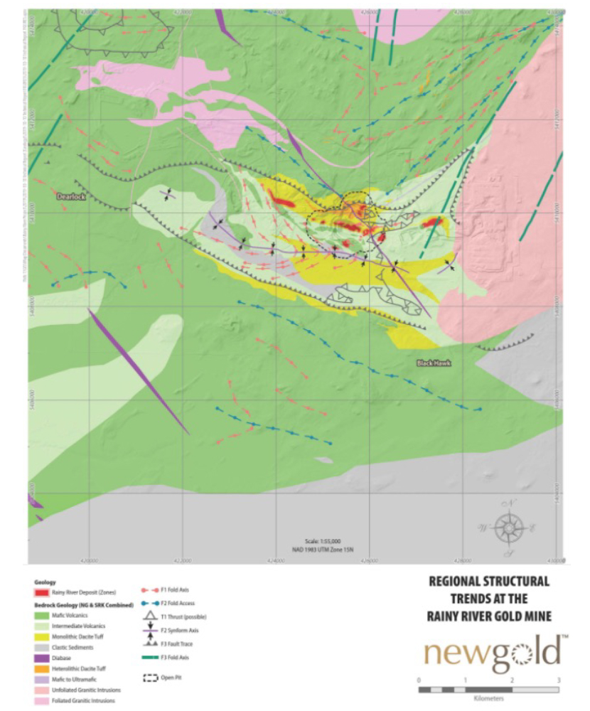
The property is located within the 2.7 billion year (Ga) old Neoarchean Rainy River Greenstone Belt (RRGB) and encompasses an approximately 30 kilometre long, north-east trending portion of the Belt. In this area, the RRGB is bounded to the north-west by the Sabaskong Batholith, to the east by the Rainy Lake Batholithic Complex and to the south by the Quetico fault.
The Rainy River deposit occurs within a sequence of felsic to intermediate metavolcanic rocks bounded to both the north and south by a lower mafic sequence. These sequences are intruded by the Sabaskong batholith to the north, and the Black Hawk stock to the east and southeast.
The current geometry and plunge of the Rainy River ore deposit are the result of several deformation events, which affect both the hosting lithologies and the features associated with the gold mineralization.
Four main styles of mineralization have been identified on the Rainy River deposit:
- Gold-bearing sulphide ± quartz stringers and veins in felsic quartz-phyric rocks;
- Quartz-ankerite-pyrite shear veins in mafic volcanic rocks;
- Sulphide-bearing silver-enriched quartz veinlets in dacitic tuffs and breccias; and
- Copper-nickel-platinum group metals mineralization hosted in a small younger mafic-ultramafic intrusion situated within the main cluster of gold and silver deposits.
The Rainy River Mine occupies approximately 6,140 hectares, comprising 100 patented mining rights and surface rights claims (including 9 leasehold interest mining rights and/or surface rights claims). In addition, the Company has a land package of approximately 30,644 hectares surrounding the mine site, including patented mining rights and/or, surface rights and unpatented claims.


